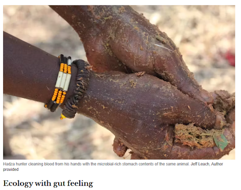
Thursday, October 17, 2024

Using Quantum GIS to be a better Nexus Thinker: A post Hurricane Reflection

 "When we began this journey, we suggested that one of the best ways to learn and practice, nay, inhabit Nexus thinking – was to experience Blender!


In my lecture 'do you speak 5D?' we showed that being keenly aware of different perspectives in X, Y, Z space, then zooming into local object details, to the level of atoms and strings, flying up and out above the underlying geometry beyond a bird's eye view – to 'infinity and beyond', moving forward and backward in the dimension of time, and exploring data layers – textures, colors, flavors of difference if you like, QUALIA  — that experience inevitably makes you hyper-aware of the nexus. Every spot you inhabit or focus on is a node, the center of the nexus, literally the center of the infinite and expanding universe, whether real or simulated. That's powerful stuff.

You are the center of the universe, and you are not.


Blender teaches the Flatlander to accept the Sphere and the Spherelander, by extension, to accept the Hypersphere and Tesseract.


But there is another, free, open-source, and stunningly useful technology that has evolved in the last couple of decades that forces the Nexus thinking perspective.

It’s called QGIS, and I’d like to show you how we can use it to do that..


GIS in general is the game changer. Geographic Information Systems involve spatial reasoning, deprivileging linearity and casual assumptions of causality, but in the past they were used primarily for 2-dimensional cartography - cladistics, making the landscape legible, as Yale Prof. James C. Scott talks about in “Seeing Like a State: How Schemes to Improve the Human Condition .Have Failed”


They were NOT used for enlightenment far too often,  but were used to delineate boundaries - who owned what where, who deserved access and why and “who should be fined or jailed or even shot dead or hanged for trespassing”.

In their attempt to simplify the landscape, Scott argued, these kind of maps often  led to DUMMIFICATION;  the maps of the landed gentry were more about ownership and inclusion and exclusion than about creating a landscape of understanding. And because of this,Scott famously  insisted, quoting Korzybski from his book "Science and Sanity" ,  “the map is not the territory”.


But GIS has grown up and with Quantum GIS, aka QGIS,  the power to choose levels of detail, and work in 5D – with multiple data layer dimensions  superimposed upon XYZ space and T space, with time series visualizations and animated 3D simulations – this power  is now available to everybody, not just the state and its agents.


It is free, and training is free just like Blender – so its power to lead us to Nexus thinking is now  democratized. If only we will embrace it.  If the birds eye view is only available from atop an ivory tower in the castle or from your leisure balloon or private jet or spy satellite then all of this marvelous technology is for naught as it will most serve further exclusion and command and control routines, and of course, more guided missile bombings and drone attacks.  At least QGIS offers the possible of that “view from 30,000 feet” for projects of the people by the people for the people.


Now it isn’t that ArcGIS Pro isn’t as powerful as a tool, but it’s so expensive you aren’t likely to use it outside of paid work – projects primarily paid for by the State that wants you to see like a State, or by the firm, the corporation, the power holder  who wants you to help them define the territory on their terms and wants you to see things their way.


When a tool is free it can encourage free thinking. QGIS is free.  And as the cyberpunk motto goes, “Information LONGS to be free”.


Marvelously Blender, that other great free software  project, first bequeathed unto the world in 1994 and made opensource for the public in 2002,  and QGIS, released 7 years later in 2009,  play well together – there is even a free  add-on for Blender that was released in 2007 called BlenderGIS that lets you work with and visualize all the shapefiles, Digital Elevation Maps, and basemap textures and geocoded images created in ArcGIS or QGIS and vice versa."


Where  GIS programs really shine as  Nexus thinking teaching environments is in the ability to create different models of reality and use geoprocessing tools to rank and consider options with weighted variables.


Imagine being able to change the terms and conditions of each possible scenario and then be able to run and rerun multiple models to observe multiple outcomes and use the model to trace the causality, to explore each influence –


Here you might weight the importance of water highest, say 60%, and food 30%, and energy only 10% – then ask what are the results. There you might flip it – energy is 60%, food 30%, water only 10%... and play the result.


What about waste – and what’s more – what about SLOPE? What about gravity?

When I get to Morocco, to the Mountains of Marrakech in the High Atlas this November, I will be starting to teach workshops in the villages in QGIS so I’m trying to learn it as quickly as possible, with an eye toward making it accessible, understandable, knowable, by people without formal education.  I have a feeling they will use it better than many ivory tower academics.  They know their landscape intimately.  If all we Nexus academics are thinking about is food, energy, and water, and possibly  waste BUT WE ARE NOT thinking about  slope and gravity, – that particular washed out road with the dangerously steep gully on the side that can kill you if you are driving a truckload of sandbags down the curvy hill and make the turn too fast –  how on earth can we help anyone?


The villagers are going through a drought and need to pump water uphill from where it has accumulated, but we have to get the pumps and pipes up and down those treacherous steep roads, and we need to power them where there is good sun or wind, and that means finding places where the mountain doesn’t block the sun with shade or block the wind. Slope and gravity and the directions of flows and accumulations of flows of water are critical parameters that must be in our models, true?

And we need to find places that offer good clean energy supplies  that aren’t so far away from the demands and  needs  that bringing that energy to a water pump or machinery or lights  isn’t prohibitively expensive. And we need to be able to run a lot of conditional queries – what if scenarios.

I’ve been to places in the Himalayan Mountains in Nepal, up on the Khumbu and Hinku valley trails near Mount Everest base camp,  where hydro seemed a logical approach, until the rivers and streams dried up or the dams silted up or the turbines got blocked by sand and grit.  I’ve been to places there where a reliance on rhododendron wood or juniper shrubs for heating and cooking led to deforestation and landscape denudation that caused catastrophic floods and landslides because the watershed got waterlogged and nobody had thought through the possible flows after saturation.

There are so many considerations that a 2D view, even if it is a bird’s eye view, even if it comes from a Google satellite view, can never capture. And that’s why the 3rd dimension of Z space is so important, and the fourth dimension of T space for time series animations is so important, and why the 5th dimension, the dimension of data layers is so important – a dimension  not just layered on like icing on a cake, but used subtly, to weigh the options.  With GIS programs data can be endlessly manipulated and the model endlessly rerun, and these layers can be almost infinitely stacked up, added, removed, and messaged to craft different messages.

QGIS enables the creation of an almost endless number of multiverses, so when you jump into it it will be like leaping like Spiderman into the Spiderverse.  You will have the power of Dr. Strange to open portals to new possibilities, and that is the power that increases the utility of Nexus Thinking. It allows a sophisticated game of 'what if.'

To use another popular metaphor, the strength of QGIS as a Nexus Thinking Box Expander is that when you run your simulations you actually DON’T  'collapse the waveform.on Schrödinger’s cat” so to speak,  so that only one solution prevails. Each model run is more like the infinite hallway inside the box in the award winning book and  Apple TV series Dark Matter...each time you enter the box you are able to think both inside and outside the box, with so many possibilities to choose from.

And that is nexus thinking.

 As a practitioner, you will be forced to choose at some point  to collapse the uncertainties and act on a result – you will have to as a project manager  “declare the metaphorical  cat alive or dead “but the pluripotency of modeling should help you, as I say,  think both outside the box and inside the box, and you know the disdain I have for the glib injunction to “think outside the box” when there is so much going on inside that you never want to exclude the known, the familiar, the tried and true…  The practice of constantly using GIS forces you to merely expand your box so you can make better iterative decisions with an ever larger data pool.

Another thing that GIS gives you is predictive power and the ability to map out strategies for problem solving.  Just think about how different the impacts of Hurricane Helene and Hurricane Milton would have been if more people were adept at thinking through the likely scenarios.  

I’ll use Austria’s recent 5000 – not 500, but 5000  year flood  as an example.

My family and I spent 10 days this summer on the River Danube, staying with friends in the apricot capital of Europe, Krems, Austria.  Krems an der Donau  is upstream from Vienna by 84 kilometers, about a 4 and half hour bike ride along the gorgeous vegetated river path called the “Treppelweg” – the ancient “towpath” where horses would pull barges filled with goods  from the city to the towns.
When you look at the two cities on a GIS satellite map you see that almost the entire floodplain is green.  The width varies from a kilometer to 6 kilometers and averages about 3 kilometers.


As we pushed our toddler’s stroller along the river up to Durnstein Castle we noted large wonderfully descriptive signs showing how Austria had been “rewilding the river” to bring back the fish and wildlife.  Everywhere we went signage told us about the significant steps the country was taking in combatting biodiversity loss and climate change.

When we returned to the US, in September 2024, Storm Boris caused flooding in Austria and other parts of Central and Eastern Europe. The Austrian province around Vienna was declared a disaster area.

“And yet,” to quote from a BBC article called “'Our plan worked': How Vienna prepared itself for a 5,000-year flood”, “ considering the onslaught of water, "we got away quite lightly", noted a Viennese journalist, referring to reports of an estimated ten lightly injured people, and 15 evacuated houses in the city. "On the whole, the [city's] ingenious flood management system resisted the masses of water," concluded another local journalist.”
The article goes on to say,“In fact, evidence from previous big floods suggests that a number of protective strategies used by Vienna, and Austria more generally, are proving effective – and offering vital lessons to others battling increasingly extreme weather.”It tells the reader,"Austria has really invested in flood management over the past decades, not least because we had two big floods, in 2002 and 2013," says Günter Blöschl, a hydrologist who has helped shape Austria's flood risk management strategy.

The article suggests that such experts are deeply engaged with the predictive models take seriously what the simulations suggest. https://www.bbc.com/future/article/20240920-our-plan-worked-how-vienna-prepared-itself-for-a-5000-year-flood

When we communicated with our friends in Krems who work in Vienna in the renewable energy sector and had taken us to visit wind and solar farms and biogas plants in their home area, they said they did fine because of all that attention to planning and respect for science and, having spent time with us in Florida, were more worried about us and the lack of preparation and respect for climate change exacerbated hurricanes.

They were right to worry.  A month later we were slammed with two back to back mega-storms.  The first claimed over 300 lives throughout the South East and caused unprecedented flooding up in North Carolina that claimed 123 lives with over 90 people still missing.  Milton has so far claimed at least 24 lives in Florida with unprecedented tornado damage to homes and trees.

People act surprised.  And yet, any capable hydrologist, looking at Flow Analysis in GIS could tell you these things were likely to happen and we, like the Austrians, could have invested the necessary money in floodplain recovery water diversion infrastructure and all sorts of adaptable engineering.  But we didn’t.
In the late 1800s and early 20th century it might be excusable.
But since the 1960s we’ve been putting satellites into orbit and since the late 1990’s back when I was in graduate school, we’ve had very powerful Geographic Information systems capable of analyzing the increasingly detailed images we are constantly taking from space in all bands of the electromagnetic spectrum  and ground truthing them with myriad environmental sensor data and personal observations.
We have cm digital elevation maps that give us exquisite and intimate understanding of the terrain and we have reems of data on the soil types, vegetation cover, geology, hydrology, you name it.  
It is simply impossible NOT to predict where the wind is likely to go, where the water is likely to go, with what strength, what volume and flow rate, what possible consequences… I mean come on people, this may be the result of rocket science, but it isn’t rocket science – it’s known physics.  It's known engineering, It’s known biology and chemistry, psychology… sociology.   We can model it all, and we can make very good predictions and we could have prepared, like they did in Vienna.

But we didn’t.  And now some ignorant yeehaws in Tennessee are threatening the lives of  FEMA volunteers in Asheville, delaying vital relief,  while Georgia House Representative and Qanon Conspiracy maven  Marjorie Taylor Greene and a failed businessman –  Mar Al Lago golfer and climate denier Donald J. Trump – suggest that the “gubbermint” is “manipulating the weather” and directing storms to hit republican areas to throw the election. These are people who don’t respect science enough to understand anthropogenic, that is, human induced climate change, but are impressed enough by the “spaghetti models” they see described by the weatherman on TV to think THAT knowledge must be power enough to control the mega-storms for nefarious purposes.

It is surreal.  Ignorance certainly  isn’t bliss when it comes to GIS modeling and predictive power, it is deadly.
But there is an antidote, and that is to put the power of geographic and systems thinking, nexus thinking, into the hands and minds of the people. And this is why QGIS, and other OPEN SOURCE and FREE GIS systems – like GRASS GIS, MapWindow GIS, SAGA GIS, ILWIS, Whitebox GAT, gvSIG, GeoDa, OpenJUMP, uDig, OrbisGIS, TerraView, DIVA-GIS, GvSIG Mobile and Marble.

Never heard of them?  Could be because you are in the casino of commerce, the good old USA where making the wealthy wealthier is our religion.  Here you hear about ArcGIS Pro and you use Apple computers with Proprietary software or Windows and Microsoft Office. And here I hear students complain that while they would love to get into GIS and modeling Nexus systems, it is too expensive.  The cost of courses in colleges is obscene and people are drowning in debt and once you graduate the investment you made in GIS won’t pay off unless you get a job in the field where your employer can afford the thousands of dollars a year in software licenses. Am I right?

But, when I travel to Europe three times a year, I hear a lot about the effective use of free OPEN SOURCE software to solve climate and planning problems.  A lot of my friends use Ubuntu (a Linux system operating software) and LibreOffice so they don’t have to pay a penny to Microsoft, and they  endlessly talk about the famous cyberpunk motto “Information Longs to be Free”.  
Most of the tutorials I watch for GIS are done by Austrians and Germans and other Europeans.
It all makes me think of those episodes in Young Sheldon when the 11 year old science prodigy travels from Texas to the University of Heidelberg and his classmates and professor call him a “dummkopf”, the slowest in the class.

It helps one answer the question “why is Europe doing a better job of mitigating and adapting to climate change?” which then leads to the question, “how can we do a better job” which leads to the question, “how can we get more people to be nexus thinkers and system thinkiers” which leads to the question “how can we get more people to invest their time, if not their money, into learning GIS so they can participate in the predictive and solution oriented possibilities… which leads to the question, “what heuristics can we use to rapidly accelerate our understanding of climate change solutions?”

As Nexus Thinkers we try to tease out all the deep interconnections between food, energy, water, ecology and waste.  Flooding in the mountains of North Carolina or the floodplains of Austria or in the High Atlas Mountains isn’t just affecting people by washing away their houses and destroying bridges and other infrastructure in the built environment – when we don’t mitigate the risk by keeping vegetation and tree cover, for example, we lose all of our topsoil to erosion, rendering agriculture difficult or impossible – you KNOW why the rivers run brown in these storms – there goes your carbon, your soil, your nutrients, swept away in the turbidity down stream.  Now try to get that organic material back upstream, back up the hill at any reasonable cost, especially when roads are washed out and bridges gone.  Hello METABOLIC RIFT.  Hello urban rural disconnect.

In a recent conversation at Gamble Creek farm in Parrish Florida while inspecting the destruction caused by Hurricane Milton which turned their greenhouse into a twisted collapsed and unlivable testimony to the destructive force of wind, we talked about how to know if soil contains the necessary 3 to 6 percent minimum organic content for healthy food production.  So much is washed away by flooding and erodied by wind – remember the dustbowl?
Going around with lab equipment and taking samples on a huge farm like Gamble Creek is cost and labor prohibitive and simply won’t happen.  But with QGIS and the suite of Satellites we now have roaming the planet from above, we can develop reasonable proxies.  

Chapt GPT came up with this list for us, saying “using QGIS and satellite imagery to assess soil health is a promising approach. There are several specific measures you can use as proxies for soil health through remote sensing and GIS techniques:

  1. Normalized Difference Vegetation Index (NDVI): This is one of the most common indices used to assess vegetation health, which indirectly reflects soil fertility. Healthy vegetation often indicates that the soil has sufficient nutrients, water, and organic matter. You can calculate NDVI using satellite images in QGIS, and it’s a good indicator of plant health and density.
  2. Soil Moisture Analysis: Using satellite-based radar or thermal data, you can estimate soil moisture content. Soil moisture is a crucial factor in soil health, as it affects plant growth and microbial activity. In QGIS, you can access soil moisture datasets from satellites like Sentinel-1 and manipulate the data to observe moisture distribution.
  3. Normalized Difference Water Index (NDWI): This index is similar to NDVI but focuses on detecting water content in vegetation or soil. Higher values of NDWI suggest that the soil retains water better, which is often a sign of good organic matter and soil structure.
  4. Land Surface Temperature (LST): High soil temperatures can indicate degraded soils with low organic matter and poor water retention. You can derive LST data from thermal sensors on satellites such as Landsat or MODIS in QGIS. Cooler soil temperatures often correspond to healthier, well-vegetated areas.
  5. Soil Organic Carbon (SOC) Estimation: SOC levels can be estimated using hyperspectral and multispectral satellite data. This data can be processed in QGIS to map areas with higher or lower organic carbon levels, which is a direct measure of soil fertility.
  6. Vegetation Condition Index (VCI): This index helps differentiate between temporary droughts and permanent soil degradation by comparing current vegetation conditions to historical norms. It can be used in QGIS to understand changes in plant health, which can reflect changes in soil quality.
  7. Spectral Analysis for Soil Properties: Advanced analysis can involve looking at specific wavelengths that correlate with soil properties such as salinity, organic matter, and nutrient content. QGIS can handle multispectral and hyperspectral data, which allows for this detailed analysis.
  8. Erosion Risk Mapping: Using digital elevation models (DEMs) in QGIS, you can analyze terrain slope, aspect, and drainage patterns to identify areas susceptible to erosion. Erosion often leads to nutrient loss, which impacts soil fertility.”

With such powerful tools now at our disposal - and these are just 8 of the hundreds available – something unprecedented in the 10,000 or so years Homo sapiens has been engaged in agriculture - we should be able to predict where problems are going to develop and mitigate when they do with relative ease.  The predicted Dustbowl 2.0 that drives people off the planet Earth in the absurd science fiction “Interstellar” need never happen.  Only idiots and grain and land speculation profit addicts would follow up on the loss of monocrop wheat by planting monocrop corn, only to see it in turn develop disease and blow away like “dust in the wind”.  And only idiots and the very poorly educated would turn to space exodus as a possible solution, searching for other inhabitable planets to mess up, instead of turning to space based satellites to reveal where the vulnerable areas are and help us decide where to apply permaculture and other techniques that can make this island Earth once again one of the most fecund and productive and biodiverse water planets in the galaxy.

I mean, come on people, we use these same GIS data streams and analyses from surface reflection and ground penetrating radar  to help predict where their might be life on Mars and the moons of Jupiter and Saturn and all those exoplanets we can see through the magic of spectral analysis.  We are using them with GIS mapping tools to decide where to hunt for water on the moon and Mars and start our first off world colonies there. Surely we can do as much and more here.  

And of course we are.  I mean SOME people are.  Earth observation satellites are up there and are being used 24/7 by dedicated scientists to figure out the weather and see where our planet is most vulnerable to erosion and flooding and fires and earthquakes and hurricanes and pollution and pests and climate change. In the second decade of the 21st century we have all the tools needed to mitigate and adapt to all sorts of terrestrial and extraterrestrial threats.  What we don’t have are all the PEOPLE necessary to participate in these conversations meaningful. There simply aren’t enough nexus thinkers out there, so we are making really bad decisions driven by the whims of profiteering real estate moguls and their political cronies telling us not to trust science and scientists much less aspire to be a scientist or learn the tools and methods of science. Nexus thinking and system thinking in general aren’t all that much help if you don’t know how to use those good intentions and awareness to actually explore realistic options and communicate them effectively.  The loudest voices will remain those of those who speculate in the casino of land-use and water-use markets rather than those who speculate scientifically on how best to develop and protect our land and water.

As a St. Petersburg journalist wrote after Milton shredded the roof of the Tropicana stadium and caused a crane to destroy a beautiful old building that helped inspire the cultural and artistic renaissance of the city decades ago,

The journalist, Thomas Hallock, who also  teaches English at USF’s St. Petersburg campus, laments,

“So what about that torn roof? $600 million could go a long way fighting the kind of storm that shredded the Trop's Teflon-coated top. We have precedents. Two-thirds of the world's metropolitan areas skirt the coast, the Global Center on Adaptation reports, and smarter municipalities have taken steps. The internet tells me that the city of Behai, in coastal China, has sunk $491 million (roughly the public tab for a stadium) into "marine ecological protection and restoration," including capital improvements to reduce pollution and nurture mangrove habitats. Boston will spend between $1.7 and $3 billion on waterfront parks, "prioritizing nature-based solutions over hard infrastructure for coastal protection." These blueprints exist for St. Petersburg. Instead, we'll build a ballpark. Instead, at my state-job at the University of South Florida, lawmakers prohibit me from even using the term "climate change."

“The images from Helene and Milton expose the depth of our folly. The offices of a local institution crushed by the crane from a ridiculous tower the city neither wants or needs. The tattered cloth roof. What are we doing? What’s happening to the city we love?”

Powerful questions that demand actionable answers. We need everyone to get involved in the iterative design that emerges from constant questioning and from multiple thought experiments – aided for the first time in the history of human civilization by geographic information systems, data and AI,  about what we should be doing to and about the cities and neighborhoods we love.

And so, finally, let’s consider the most salient powers that QGIS has to improve your life and all our lives.  The powerful models push us to … and this picks up on our previous lecture –  push us  to embrace.the power of heuristics 

Heuristics, you may recall, can be both fast and frugal, acting as rules of thumb that help you make quick decisions without having to spend the time or effort to really think things through AND as long-term well thought out plans of action that improve  through iterative design and reflection, through endlessly questioning and reassessing.

And we use this term for both phenomenon, in a Necker cube fashion,  because heuristics comes from the Greek idea of 'DISCOVERY.  Etymologically  “heuristic” means 'to find or discover' It is a method of nexus thinking where you find or discover or uncover rules or methods that come from experience and heuristics helps  you think through things like the process of elimination or the process of trial and error.

You can think of heuristics as both a shortcut and a lifelong journey.
It is a shortcut, because once you've run the model in your head or computer or in your LIVED  reality and found a positive result, you can run that model again fast and frugally.

But it is also lifelong, because every result leads to further questions that lead to questions and adjustment, sending you back to the drawing board to redraw, rerunning the model because reality changes all the time and the map no longer fits.

QGIS fosters Nexus Thinking.  QGIS fosters engagement with the world around you, past present and possible future.

 The map is not the territory, but through QGIS we can now ALL map out different territories, different consequences, different realities, and then come together to decide which version or versions to bring to life in our local environments – versions more appropriate to the needs of each community because we share our diverse visions and make them one, E PLURIBUS UNUM.  Get into GIS today and let's make a better tomorrow for everyone.

Using Quantum GIS to be a better Nexus Thinker: A post Hurricane Reflection

  "When we began this journey, we suggested that one of the best ways to learn and practice, nay,   inhabit  Nexus thinking – was to ex...